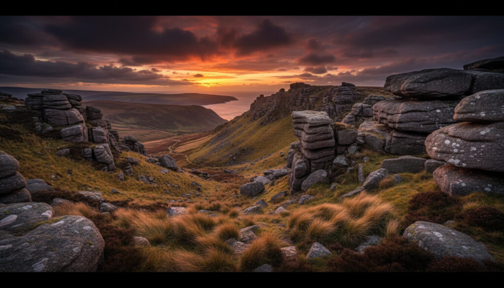
Valley of the Rocks – Exmoor’s Dramatic Natural Wonder
Valley of the Rocks stands as one of North Devon’s most dramatic coastal landscapes. This rugged, U-shaped dry valley lies within Exmoor National Park, positioned roughly half a mile west of Lynton, where jagged cliffs and ancient rock formations rise above the Bristol Channel. Unlike typical valleys carved by persistent waterways, this geological anomaly presents a riverless ravine surrounded by towering sandstone crags that have attracted naturalists and hikers for centuries.
The site’s distinctive character stems from both its Ice Age origins and its current inhabitants. Feral goats, documented in the area since the 11th-century Domesday Book, roam freely across the 500-foot elevation, grazing on precipitous slopes where few other mammals dare venture. The valley offers a network of hiking trails ranging from brief 30-minute loops to strenuous 3.7-mile circuits, all providing panoramic coastal views that shift dramatically with the seasons.
Access requires no admission fee, positioning the valley as an accessible natural attraction. Visitors arrive via narrow roads from Lynton and Lynmouth, though local documentation recommends approaching on foot through woodland paths for the most striking initial views of the valley’s expanse.
Where is Valley of the Rocks and How to Get There?
The Valley of the Rocks sits within the boundaries of Exmoor National Park in North Devon, approximately 0.8 kilometers west of Lynton. The site borders the Bristol Channel, offering elevated coastal vistas from its 152-meter height above sea level. This proximity to Lynton and its twin village Lynmouth makes the valley an integral part of the region’s tourism infrastructure.
| Location | Exmoor National Park, North Devon, ½ mile west of Lynton |
| Key Feature | U-shaped dry valley at 500ft (152m) elevation |
| Access | Free entry; pay-and-display parking available |
| Highlights | Coastal views, feral goats, climbable rock formations |
- Riverless formation: Despite its U-shaped profile, no river flows through the valley, a result of Ice Age glacial diversion.
- Primary parking: The Valley of the Rocks car park (EX35 6JH) serves as the main trailhead with toilet facilities.
- Alternative access: Street parking exists in Lynton along Lynmouth Hill, Castle Hill, Church Hill, Lee Road, and Cross Street.
- Public transport: Bus services connect to Lynton and Lynmouth, requiring a short walk or drive to reach the valley.
- Visibility windows: Feral goats remain present year-round but prove more visible during quieter morning and evening periods.
- Summer congestion: Weekend visits between June and August experience the highest visitor density.
- Approach recommendation: Walking from Lynton via woodland paths offers superior initial views compared to driving directly to the car park.
| Attribute | Details |
|---|---|
| Location | Exmoor National Park, North Devon |
| Distance from Lynton | ½ mile (0.8 km) west |
| Elevation | 500 ft (152 m) above sea level |
| Valley Type | U-shaped dry valley (riverless) |
| Formation Period | Ice Age, 120,000–200,000 years ago |
| Parking Postcode | EX35 6JH |
| Entry Fee | Free |
| Goat Heritage | Present since 11th-century Domesday Book |
| Primary Rock Features | Castle Rock, Rugged Jack, White Lady, Devil’s Cheese Ring |
| Trail Range | 2.5 km to 6 km (1.5 to 3.7 miles) |
| Facilities | Toilets at car park and Lynton end; seasonal café |
| Optimal Seasons | Spring and Autumn |
What is Valley of the Rocks?
The Valley of the Rocks represents a geological curiosity within the British landscape. Formed during the Ice Age between 120,000 and 200,000 years ago, the valley emerged when an ice sheet diverted the East Lyn River westward. When the ice retreated, it left a dry, U-shaped ravine rather than a traditional water-carved valley. Silt accumulation subsequently shaped the terrain, creating the distinctive formations visible today.
Geological Origins
Research indicates that glacial activity played an indirect role in the valley’s formation. Rather than direct glacial carving, the ice sheet acted as a hydrological barrier, forcing the river to alter its course. This process, combined with post-glacial sediment deposition, resulted in the current topography. The surrounding cliffs and rock stacks consist of ancient sedimentary deposits that predate the valley itself, though the specific valley formation dates to the Pleistocene epoch.
The British Geological Survey and Exmoor National Park authorities document these processes, distinguishing the site from typical glacial troughs despite its U-shaped appearance. The valley’s dry nature confuses many visitors expecting a flowing waterway at its base.
Distinctive Rock Formations
Several named formations punctuate the landscape. Castle Rock offers a climbable ascent via a steep, rocky path leading to a viewpoint platform. Rugged Jack, the White Lady, and the Devil’s Cheese Ring represent other significant features, each presenting unique silhouettes against the coastal horizon. Caves dot the cliff faces, including Mother Meldrum’s Cave, accessible via the circular walking route.
Despite its U-shaped profile typical of glacial valleys, the Valley of the Rocks formed primarily through river diversion and silt accumulation rather than direct glacial carving. The Ice Age ice sheet redirected the East Lyn River westward, leaving this dry ravine when the ice retreated approximately 120,000 years ago.
Valley of the Rocks Walks and Hiking Trails
The valley provides multiple hiking options varying in length and difficulty. Trails range from accessible short walks suitable for families to more demanding circuits requiring moderate fitness levels. All routes share common characteristics: steep gradients, exposure to coastal winds, and proximity to cliff edges.
The Lynton Outer Loop
This circuit begins at the Lynton trailhead, proceeding along the rugged coastline before entering the valley proper. The route passes Lee Abbey, a Gothic structure visible from the path, and incorporates steep climbs with views across the Bristol Channel. Trail markers remain adequate though not extensive. The path accommodates families with pets on leashes, though crowding peaks during summer weekends.
Short Trail from Lynton
Measuring 2.5 kilometers, this route follows the South West Coast Path to the valley before ascending Hollerday Hill via a zig-zag path back to the starting point. The hike highlights the Castle Rock climb and close-up views of the primary rock formations. This option suits visitors seeking a condensed experience without committing to longer circuits.
Circular Walk from the Car Park
Starting from the Valley of the Rocks car park (EX35 6JH), this 3.7-mile (6-kilometer) route involves 300 meters of ascent and moderate grading. The trail enters woodlands, ascends via switchbacks up South Cleave, and passes Mother Meldrum’s Cave and the ruins of Hollerday House before returning to the valley floor. This route offers the most comprehensive geological and historical overview.
Paths throughout the valley feature steep, rocky sections with sheer drops. Visitors must supervise children and dogs closely, particularly near cliff edges. Certain routes present vertigo-inducing exposures unsuitable for those with mobility limitations or fear of heights.
Wildlife in Valley of the Rocks: The Famous Goats
The feral goat population constitutes the valley’s most charismatic wildlife attraction. Historical records document their presence since at least the 11th century, appearing in the Domesday Book. These animals have adapted to the precipitous terrain, often observed grazing on seemingly inaccessible cliff ledges or hopping between rock outcrops with remarkable agility.
The goats exist as a wild, unmanaged herd, distinct from domesticated agricultural stock. Their presence contributes to the valley’s ecological management through grazing, though they remain wild animals requiring respectful observation distances. The habitat supports additional wildlife typical of Exmoor’s coastal fringe, though the goats dominate visitor attention.
The feral goat herd proves most visible during early morning and late afternoon hours, particularly outside peak summer weekends. While the animals appear habituated to human presence, maintaining a respectful distance remains essential for both visitor safety and animal welfare.
Visitors planning other UK attractions might consider a Harry Potter Tour London for a contrasting urban experience after exploring this natural landscape.
Best Time to Visit and Practical Tips
The valley operates as a year-round destination, though seasonal variations significantly impact the experience. Spring and autumn provide optimal conditions: milder temperatures, reduced visitor numbers, and enhanced opportunities for goat sightings as the animals forage more actively during daylight hours. Summer brings dense crowds, particularly on weekends, while winter weather can render paths slippery and hazardous.
Entry to the National Park site remains free, though the car park operates on a pay-and-display basis. Visitors should note that the café and toilet facilities at the Lynton end (near Mother Meldrum’s Cave) operate seasonally. Benches line the steeper paths, offering necessary rest points. A minimalist 30-minute loop exists for those with limited time or mobility.
Approaching on foot from Lynton woods provides the classic valley overlook view that drivers miss when parking directly at the site. Visitors should maintain distance from both cliff edges and the goat herd, as the terrain presents genuine fall risks and the animals remain wild despite their apparent tameness.
Historical Timeline of Valley of the Rocks
- : Ice Age glaciation diverts the East Lyn River, initiating valley formation.
- : Ice sheet retreat leaves a dry, U-shaped ravine; silt accumulation shapes the current terrain.
- : The Domesday Book records feral goat populations in the area.
- : Exmoor National Park Authority manages the site as a premier hiking destination.
Established Facts and Ongoing Questions
| Verified Information | Uncertain or Variable Details |
|---|---|
| Valley formed via Ice Age river diversion 120,000–200,000 years ago | Exact current population count of the feral goat herd |
| Free entry to the National Park site | Frequency and reliability of public bus services to the trailhead |
| Goats present since 11th-century Domesday Book | Seasonal fluctuations in daily visitor numbers |
| Specific names and locations of rock formations (Castle Rock, etc.) | Precise geological dating of individual rock stacks vs. valley floor |
| Official trail distances and elevation measurements | Long-term management plans for the feral goat population |
| Car park postcode EX35 6JH and facility locations | Operational status of the seasonal café (periodically listed for sale) |
The Valley Within Exmoor’s Landscape
The Valley of the Rocks occupies a unique position within Exmoor National Park’s coastal zone. Unlike the wooded combes and river valleys that characterize much of Exmoor, this dry valley presents an anomalous open landscape. Its proximity to Lynton and Lynmouth integrates the site into a broader tourism circuit that includes Glen Lyn Gorge and the South West Coast Path.
The site contrasts with nearby attractions such as the Glen Lyn Gorge (1.1 miles distant), which features water-carved formations rather than dry, wind-sculpted profiles. The Lynton Toy Museum (0.8 miles) and the 21 Mile Drive (1.1 miles) offer complementary experiences, though neither matches the valley’s combination of geological spectacle and free-roaming wildlife. The Exmoor National Park Centre in Lynmouth provides additional context for visitors seeking to understand the valley’s place within the park’s conservation framework.
Documentation and Verification
Information regarding the Valley of the Rocks derives from multiple authoritative sources. Exmoor National Park maintains official documentation regarding trail conditions and conservation status. Geological interpretations rely on surveys documenting the Ice Age diversion of the East Lyn River and subsequent silt deposition patterns.
Historical records confirm the presence of feral goats in the region since the Domesday Book of 1086, establishing one of Britain’s oldest continuous populations of free-roaming ungulates within a protected landscape.
— Visit Exmoor Official Documentation
Contemporary visitor data and trail specifications originate from hiking guides and tourism boards, including detailed route descriptions for the circular walk and Lynton Outer Loop. Accessibility limitations and safety warnings reflect ongoing assessments by park authorities and visitor feedback aggregated through tourism platforms.
Planning Your Visit
The Valley of the Rocks delivers a distinctive Exmoor experience combining rare geology, accessible hiking, and guaranteed wildlife encounters. Free entry and multiple trail options accommodate various fitness levels, though the terrain demands caution near cliff edges. Spring and autumn visits offer optimal conditions, while the EX35 6JH car park provides the most convenient access point. Whether observing the ancient feral goat herd or climbing Castle Rock for coastal views, visitors should allocate at least two hours to appreciate the site’s full scope. Those needing nearby services can search for a Cash Point Near Me in Lynton before heading to the trailhead.
Common Questions
How long is the Valley of the Rocks walk?
Trail distances range from a 2.5-kilometer short loop to a 3.7-mile (6-kilometer) circular route with 300 meters of ascent. A minimal 30-minute loop exists for constrained schedules.
Is Valley of the Rocks free to enter?
Yes, entry to the National Park site is free. However, the Valley of the Rocks car park operates on a pay-and-display basis, and alternative street parking in Lynton may have time restrictions.
Can you see the goats all year round?
The feral goat herd resides in the valley throughout the year. Visibility improves during spring and autumn mornings or evenings when crowds diminish and animals forage actively.
Where do you park for Valley of the Rocks?
Use the Valley of the Rocks car park (postcode EX35 6JH) near the cricket ground, which includes toilet facilities. Alternatively, park in Lynton and walk via the South West Coast Path.
Is Valley of the Rocks wheelchair accessible?
Steep, rocky sections and cliff edges limit wheelchair and mobility access. Some paths near the car park remain manageable, but vertigo-prone areas and uneven terrain restrict full site accessibility.
What caused the Valley of the Rocks to form?
During the Ice Age, an ice sheet diverted the East Lyn River westward. When the ice retreated 120,000–200,000 years ago, it left a dry, U-shaped ravine shaped by silt accumulation rather than glacial carving or river erosion.
What is the best time to visit?
Spring and autumn provide ideal visiting conditions with milder weather, fewer crowds, and active wildlife. Summer weekends experience peak congestion, while winter conditions can make paths hazardous.
More related posts
 Your Friends and Neighbors Guide: Cast, Season 2 & Reviews
 How to register with a GP: Ireland & UK guide (2025)
 Barber Shops Near Me – Walk-Ins, Best Rated & Open Now
 Air India Plane Crash Pilot – Cause Theories and Updates
 BBC Sport Cricket Scores: Live Updates and Fixtures
 F1 (Film): Brad Pitt’s Driving, Real Story & Netflix
 Things to Do in Porto – Top Attractions and Itineraries
 Isle of Skye Weather: Best Month, Rainfall, Midges & Storm Amy Guide
